Fort Union National Monument
Fort Union National Monument preserves the remains of a nineteenth-century military post that played an important role in the protection of travel and commerce along the Santa Fe Trail. Established in northeastern New Mexico, the fort became a logistical and military center serving both transportation networks and frontier operations. The site reflects the strategic importance of overland routes that connected communities across the Southwest.
The preserved adobe ruins illustrate the scale of the post and the practical architectural methods used in an arid environment. Fort Union supported wagon traffic, military patrols, and supply distribution, helping to reinforce federal presence in a region shaped by trade, migration, and conflict. The remains of the fort provide insight into the changing patterns of movement and infrastructure across the nineteenth-century frontier.
Visitors encounter broad grassland surroundings and low adobe walls that convey both the scale and vulnerability of the site. The open landscape helps place the fort within the larger geography of travel corridors and frontier settlement, illustrating the connection between architecture, military strategy, and regional development.

A stone-paved path runs diagonally beside a long range of adobe ruins, guiding the eye from the nearer foundations toward taller remains farther away. The repeated wall fragments establish the scale of the former complex, while the path marks a visitor route through the site. This oblique viewpoint emphasizes the length and alignment of the ruins rather than a single façade or architectural detail.
Caption
A stone-paved path runs diagonally beside a long range of adobe ruins, guiding the eye from the nearer foundations toward taller remains farther away. The repeated wall fragments establish the scale of the former complex, while the path marks a visitor route through the site. This oblique viewpoint emphasizes the length and alignment of the ruins rather than a single façade or architectural detail.

Low adobe walls extend across an open grassland, their broken outlines set against a distant line of trees. From this wide viewpoint the remains appear as a low horizontal band rather than isolated architectural details, emphasizing how the former fort occupies the broad plain. The muted earth tones of the masonry blend with the dry ground, while the greener foreground and tree line mark the landscape around the ruins.
Caption
Low adobe walls extend across an open grassland, their broken outlines set against a distant line of trees. From this wide viewpoint the remains appear as a low horizontal band rather than isolated architectural details, emphasizing how the former fort occupies the broad plain. The muted earth tones of the masonry blend with the dry ground, while the greener foreground and tree line mark the landscape around the ruins.

Three wild turkeys walk across dry grass beneath dense leafless branches. Their dark bodies and bare red heads stand out against the muted winter ground, while the birds’ different orientations suggest movement through the brush rather than a posed group. The open foreground gives the flock room and keeps the scrubby woodland setting visible.
Caption
Three wild turkeys walk across dry grass beneath dense leafless branches. Their dark bodies and bare red heads stand out against the muted winter ground, while the birds’ different orientations suggest movement through the brush rather than a posed group. The open foreground gives the flock room and keeps the scrubby woodland setting visible.

The panel titled “A Living View” combines a panoramic landscape image with labels for nearby mountains and geological features. Its text discusses prairie water, vegetation, wildlife, and the transition between the Great Plains and Rocky Mountains. A fence recedes across the pictured grassland, linking the interpretive map and labels to the open terrain around the monument.
Caption
The panel titled “A Living View” combines a panoramic landscape image with labels for nearby mountains and geological features. Its text discusses prairie water, vegetation, wildlife, and the transition between the Great Plains and Rocky Mountains. A fence recedes across the pictured grassland, linking the interpretive map and labels to the open terrain around the monument.

A single male wild turkey strides across the foreground, its long legs and rounded body clearly separated from the tangle of pale branches behind it. The red head and blue facial skin contrast with glossy dark plumage, while a barred tail and wing add texture. This closer portrait isolates the bird from the group seen earlier on the page.
Caption
A single male wild turkey strides across the foreground, its long legs and rounded body clearly separated from the tangle of pale branches behind it. The red head and blue facial skin contrast with glossy dark plumage, while a barred tail and wing add texture. This closer portrait isolates the bird from the group seen earlier on the page.

A tall chimney stack rises directly above a broad surviving adobe wall, creating a strong vertical profile among lower fragments of the fort. The exposed brickwork at the stack contrasts with the earth-toned wall beneath it, making the junction between chimney and masonry especially prominent. Other remnants remain scattered nearby, but this paired wall-and-chimney form anchors the view and distinguishes it from broader ruin panoramas.
Caption
A tall chimney stack rises directly above a broad surviving adobe wall, creating a strong vertical profile among lower fragments of the fort. The exposed brickwork at the stack contrasts with the earth-toned wall beneath it, making the junction between chimney and masonry especially prominent. Other remnants remain scattered nearby, but this paired wall-and-chimney form anchors the view and distinguishes it from broader ruin panoramas.

Two tall chimney stacks rise above an extended line of adobe ruins beside a stone-paved path. The path leads diagonally through the scene and gives the broken wall range a clear sense of scale and direction. Compared with a distant panorama, this view brings the paired chimneys closer and shows their relationship to the route through the site, while smaller wall fragments continue along the ground.
Caption
Two tall chimney stacks rise above an extended line of adobe ruins beside a stone-paved path. The path leads diagonally through the scene and gives the broken wall range a clear sense of scale and direction. Compared with a distant panorama, this view brings the paired chimneys closer and shows their relationship to the route through the site, while smaller wall fragments continue along the ground.

A regional map places Fort Union near the upper right and plots a network of forts across the Southwest. Names including Fort Garland, Fort Lowell, Fort Craig, and Fort Sumner are legible, with dotted routes linking many locations. Photographed straight on, the map makes the network and Fort Union’s position its central subject; its pale surface shows slight glare from the exhibit lighting.
Caption
A regional map places Fort Union near the upper right and plots a network of forts across the Southwest. Names including Fort Garland, Fort Lowell, Fort Craig, and Fort Sumner are legible, with dotted routes linking many locations. Photographed straight on, the map makes the network and Fort Union’s position its central subject; its pale surface shows slight glare from the exhibit lighting.

The aerial image reveals a rectilinear complex of low walls and foundations scattered across open grassland. A caption printed over the photograph identifies the remains of the Third Fort and arsenal as a large collection of nineteenth-century adobe structures. The elevated viewpoint makes the overall layout visible, connecting individual ruins to the broader fortified site.
Caption
The aerial image reveals a rectilinear complex of low walls and foundations scattered across open grassland. A caption printed over the photograph identifies the remains of the Third Fort and arsenal as a large collection of nineteenth-century adobe structures. The elevated viewpoint makes the overall layout visible, connecting individual ruins to the broader fortified site.

The interpretive diagram titled “The End of the Road” focuses on the depot’s transportation corral, mapping wagon routes and service areas at the end of a supply journey. Labels identify distinct zones within the compound, while explanatory text runs along the left side. This close view of the panel highlights the movement and staging of freight rather than the broader fort layout.
Caption
The interpretive diagram titled “The End of the Road” focuses on the depot’s transportation corral, mapping wagon routes and service areas at the end of a supply journey. Labels identify distinct zones within the compound, while explanatory text runs along the left side. This close view of the panel highlights the movement and staging of freight rather than the broader fort layout.

The panel pairs a plan of the hospital complex with short historical text under the heading “The Best Hospital in 500 Miles.” Its labeled rooms and open desert background connect the medical facility to the larger Fort Union story. Read as an interpretive display, the panel foregrounds the hospital’s role in a remote nineteenth-century military post.
Caption
The panel pairs a plan of the hospital complex with short historical text under the heading “The Best Hospital in 500 Miles.” Its labeled rooms and open desert background connect the medical facility to the larger Fort Union story. Read as an interpretive display, the panel foregrounds the hospital’s role in a remote nineteenth-century military post.

A large male wild turkey fans its barred tail and turns its iridescent body in a display, while a second bird stands close beside it. Sunlight catches bronze, green, and copper tones in the feathers, and the birds’ red and blue head skin is sharply visible. The tight framing makes courtship-like display behavior the central detail.
Caption
A large male wild turkey fans its barred tail and turns its iridescent body in a display, while a second bird stands close beside it. Sunlight catches bronze, green, and copper tones in the feathers, and the birds’ red and blue head skin is sharply visible. The tight framing makes courtship-like display behavior the central detail.

Two male wild turkeys fill the frame, their bare red and blue heads nearly aligned as they move through dry grass. Their dark, iridescent bodies show copper and green highlights, and the nearer bird’s barred wing and tail feathers form a strong pattern against the pale ground. The paired composition emphasizes their scale and plumage.
Caption
Two male wild turkeys fill the frame, their bare red and blue heads nearly aligned as they move through dry grass. Their dark, iridescent bodies show copper and green highlights, and the nearer bird’s barred wing and tail feathers form a strong pattern against the pale ground. The paired composition emphasizes their scale and plumage.

A small, dark timber outbuilding stands in a wide snow-covered field beneath a low gray sky. Its pitched roof and open-looking side contrast with the nearly featureless white ground, while a distant line of low hills anchors the horizon. The isolated structure is the only strong vertical element in this expansive winter landscape.
Caption
A small, dark timber outbuilding stands in a wide snow-covered field beneath a low gray sky. Its pitched roof and open-looking side contrast with the nearly featureless white ground, while a distant line of low hills anchors the horizon. The isolated structure is the only strong vertical element in this expansive winter landscape.

The display titled “From Indigenous Trail to International Highway” combines a route map with text about the Santa Fe Trail’s changing use. The map links places across the central plains and New Mexico, while the panel describes travel, trade, and later transportation routes. Its layout turns a long regional history into a mapped sequence of connections.
Caption
The display titled “From Indigenous Trail to International Highway” combines a route map with text about the Santa Fe Trail’s changing use. The map links places across the central plains and New Mexico, while the panel describes travel, trade, and later transportation routes. Its layout turns a long regional history into a mapped sequence of connections.

The mural shows covered wagons, draft animals, and mounted travelers moving together across a grassy landscape. The repeated wagons and riders form a broad horizontal procession, with the foremost figures rendered larger to draw the eye into the scene. As an interpretive illustration, it evokes the overland traffic associated with the Santa Fe Trail without presenting a documentary view.
Caption
The mural shows covered wagons, draft animals, and mounted travelers moving together across a grassy landscape. The repeated wagons and riders form a broad horizontal procession, with the foremost figures rendered larger to draw the eye into the scene. As an interpretive illustration, it evokes the overland traffic associated with the Santa Fe Trail without presenting a documentary view.

The interpretive panel “Community Sprouts Roots” presents how trail traffic and military activity contributed to settlements along the route. A broad prairie photograph runs across the middle, while smaller archival images and place labels line the lower section. The combination of narrative text, landscape, and historic buildings connects the trail’s movement to permanent communities.
Caption
The interpretive panel “Community Sprouts Roots” presents how trail traffic and military activity contributed to settlements along the route. A broad prairie photograph runs across the middle, while smaller archival images and place labels line the lower section. The combination of narrative text, landscape, and historic buildings connects the trail’s movement to permanent communities.

Two brown signs stand in tawny grassland. The upper panel reads “Mountain Branch Trail Ruts,” and the lower identifies the Santa Fe National Historic Trail. Beyond the posts, parallel depressions cut across the open ground, making the historic route visible as a subtle landscape feature rather than a constructed road.
Caption
Two brown signs stand in tawny grassland. The upper panel reads “Mountain Branch Trail Ruts,” and the lower identifies the Santa Fe National Historic Trail. Beyond the posts, parallel depressions cut across the open ground, making the historic route visible as a subtle landscape feature rather than a constructed road.

Several long, shallow parallel depressions run across a pale grassland slope, separated by low ridges of dry soil and vegetation. A fence follows the upper ground, and a lone shrub punctuates the open horizon. The close, low viewpoint makes the repeated tracks legible as surface impressions in the prairie.
Caption
Several long, shallow parallel depressions run across a pale grassland slope, separated by low ridges of dry soil and vegetation. A fence follows the upper ground, and a lone shrub punctuates the open horizon. The close, low viewpoint makes the repeated tracks legible as surface impressions in the prairie.

A long, low mountain with a light dusting of snow sits beyond an expansive tan plain. A thin line of trees and small buildings separates the foreground grassland from the distant slope, while muted winter light softens the horizon. The composition emphasizes the wide open basin and the modest rise of the mountain rather than a close architectural subject.
Caption
A long, low mountain with a light dusting of snow sits beyond an expansive tan plain. A thin line of trees and small buildings separates the foreground grassland from the distant slope, while muted winter light softens the horizon. The composition emphasizes the wide open basin and the modest rise of the mountain rather than a close architectural subject.

The “Tides of Change” panel arranges scenes from different periods across a pale map-like background. Small illustrations show Indigenous life, animal-drawn travel, a wagon, and later transportation, while dated headings divide the story into eras. The display’s repeated figures and vehicles frame regional change through movement and settlement rather than through a single battle or building.
Caption
The “Tides of Change” panel arranges scenes from different periods across a pale map-like background. Small illustrations show Indigenous life, animal-drawn travel, a wagon, and later transportation, while dated headings divide the story into eras. The display’s repeated figures and vehicles frame regional change through movement and settlement rather than through a single battle or building.

The panel titled “Fort Union’s Strength” pairs a historic regional map with small archival photographs and explanatory text. Its layout places Fort Union within a network of routes and military sites, while the text describes the fort’s establishment and role on the Santa Fe Trail. The map and images turn the military post into part of a wider territorial system.
Caption
The panel titled “Fort Union’s Strength” pairs a historic regional map with small archival photographs and explanatory text. Its layout places Fort Union within a network of routes and military sites, while the text describes the fort’s establishment and role on the Santa Fe Trail. The map and images turn the military post into part of a wider territorial system.

A woman walks beside a long, waist-high interpretive display whose angled metal face is turned away from the camera. Dry prairie extends behind her to a low, level horizon, and the sandy path cuts through the grass. The scene records a visitor moving through the site, with the sign structure and open setting providing context.
Caption
A woman walks beside a long, waist-high interpretive display whose angled metal face is turned away from the camera. Dry prairie extends behind her to a low, level horizon, and the sandy path cuts through the grass. The scene records a visitor moving through the site, with the sign structure and open setting providing context.

Bold orange, cream, and dark tones turn the fort and a wheeled cannon into a graphic illustration. Large lettering reads “Fort Union National Monument,” with “New Mexico” along the bottom edge. The simplified shapes, strong color blocks, and poster-like composition distinguish this designed image from documentary photographs of the actual ruins.
Caption
Bold orange, cream, and dark tones turn the fort and a wheeled cannon into a graphic illustration. Large lettering reads “Fort Union National Monument,” with “New Mexico” along the bottom edge. The simplified shapes, strong color blocks, and poster-like composition distinguish this designed image from documentary photographs of the actual ruins.

A small herd of pronghorn spreads across tawny grassland, with several animals grazing while others stand alert. Their pale rumps and slender bodies contrast with the dry vegetation, and the wide framing keeps the herd’s spacing and open habitat in view. The animals occupy a low band across the frame, emphasizing the breadth of the prairie.
Caption
A small herd of pronghorn spreads across tawny grassland, with several animals grazing while others stand alert. Their pale rumps and slender bodies contrast with the dry vegetation, and the wide framing keeps the herd’s spacing and open habitat in view. The animals occupy a low band across the frame, emphasizing the breadth of the prairie.

Two pronghorn stand shoulder to shoulder amid waist-high tawny grass, both turning their heads toward the camera. Their dark facial markings, white neck patches, and short forked horns are visible. The tighter crop gives the pair more presence than the herd view on the same page and makes their alert posture the defining feature.
Caption
Two pronghorn stand shoulder to shoulder amid waist-high tawny grass, both turning their heads toward the camera. Their dark facial markings, white neck patches, and short forked horns are visible. The tighter crop gives the pair more presence than the herd view on the same page and makes their alert posture the defining feature.

A distant row of low earthen walls, broken openings, and narrow chimneys stretches across the prairie. Their repeated adobe forms sit below a clear blue sky, with dry grass and faint tracks in the foreground. The long view conveys the ruins’ scale and their exposed setting, while keeping individual rooms and construction details indistinct.
Caption
A distant row of low earthen walls, broken openings, and narrow chimneys stretches across the prairie. Their repeated adobe forms sit below a clear blue sky, with dry grass and faint tracks in the foreground. The long view conveys the ruins’ scale and their exposed setting, while keeping individual rooms and construction details indistinct.

A dark brown marker mounted between heavy timber posts stands in dry grassland. The heading identifies Fort Union National Monument and gives the dates 1851–1891; smaller text summarizes the site’s history. The close view brings the weathered sign and its lettering forward while leaving the open prairie visible around it.
Caption
A dark brown marker mounted between heavy timber posts stands in dry grassland. The heading identifies Fort Union National Monument and gives the dates 1851–1891; smaller text summarizes the site’s history. The close view brings the weathered sign and its lettering forward while leaving the open prairie visible around it.

A dark interpretive plaque reading “Fort Union Arsenal” hangs between rounded timber posts in the open grassland. The sign’s body text sits against a pale landscape, with a low ridge at the horizon and a fence crossing behind it. This closer, centered composition separates the arsenal marker from the broader monument sign shown immediately before it.
Caption
A dark interpretive plaque reading “Fort Union Arsenal” hangs between rounded timber posts in the open grassland. The sign’s body text sits against a pale landscape, with a low ridge at the horizon and a fence crossing behind it. This closer, centered composition separates the arsenal marker from the broader monument sign shown immediately before it.

A broad adobe-colored entrance wall carries the words “Fort Union National Monument and Santa Fe National Historic Trail.” A small National Park Service arrowhead appears at left, and hours are posted beneath the main lettering. The low wall sits against pale grassland and a blue sky, functioning as a clear entrance and designation marker.
Caption
A broad adobe-colored entrance wall carries the words “Fort Union National Monument and Santa Fe National Historic Trail.” A small National Park Service arrowhead appears at left, and hours are posted beneath the main lettering. The low wall sits against pale grassland and a blue sky, functioning as a clear entrance and designation marker.

The panel’s “West” section combines a route map with numbered stops, historic photographs, and a portrait labeled for trail history. Its graphics follow the Santa Fe Trail toward New Mexico, pairing places with brief descriptions and images. The display presents the route as a sequence of landscapes and settlements rather than a single continuous scene.
Caption
The panel’s “West” section combines a route map with numbered stops, historic photographs, and a portrait labeled for trail history. Its graphics follow the Santa Fe Trail toward New Mexico, pairing places with brief descriptions and images. The display presents the route as a sequence of landscapes and settlements rather than a single continuous scene.

This companion display, headed “North and East,” maps trail routes from the New Mexico region toward the plains. Archival scenes, small site photographs, and labeled stops fill the panel around colored route lines. Its orientation and imagery distinguish it from the westward route panel beside it, extending the exhibit’s view of the trail network.
Caption
This companion display, headed “North and East,” maps trail routes from the New Mexico region toward the plains. Archival scenes, small site photographs, and labeled stops fill the panel around colored route lines. Its orientation and imagery distinguish it from the westward route panel beside it, extending the exhibit’s view of the trail network.

A long adobe complex rises from the prairie, its roofless rooms, broken parapets, and empty doorways silhouetted against a pale blue sky. Wooden braces support some exposed walls, while a low white fence marks the visitor boundary. The straight-on view makes the repeated rooms and weathered earthen construction the focus.
Caption
A long adobe complex rises from the prairie, its roofless rooms, broken parapets, and empty doorways silhouetted against a pale blue sky. Wooden braces support some exposed walls, while a low white fence marks the visitor boundary. The straight-on view makes the repeated rooms and weathered earthen construction the focus.

A dark field cannon with large spoked wheels rests on a rectangular pad in front of a low adobe-colored building with a shaded porch. The cannon’s barrel points left, and its iron frame contrasts with the building’s stucco walls and red roof trim. The display places military equipment in the modern visitor area without establishing the weapon’s date or provenance.
Caption
A dark field cannon with large spoked wheels rests on a rectangular pad in front of a low adobe-colored building with a shaded porch. The cannon’s barrel points left, and its iron frame contrasts with the building’s stucco walls and red roof trim. The display places military equipment in the modern visitor area without establishing the weapon’s date or provenance.

A single pronghorn stands in tawny grass and looks toward the camera, its short dark horns and pale throat patch visible against a blue sky. An interpretive banner above the photograph notes the animal’s speed, placing a wildlife portrait within the monument’s educational displays. The animal’s upright posture and open habitat remain the image’s primary visual details.
Caption
A single pronghorn stands in tawny grass and looks toward the camera, its short dark horns and pale throat patch visible against a blue sky. An interpretive banner above the photograph notes the animal’s speed, placing a wildlife portrait within the monument’s educational displays. The animal’s upright posture and open habitat remain the image’s primary visual details.

A large sepia-toned panel centers on a colored route map that branches across the plains toward New Mexico. Small historic photographs and a wagon-train illustration surround the map, while place labels mark the route. The display’s warm palette and broad geographic scope make the trail network, rather than one fort building, the subject.
Caption
A large sepia-toned panel centers on a colored route map that branches across the plains toward New Mexico. Small historic photographs and a wagon-train illustration surround the map, while place labels mark the route. The display’s warm palette and broad geographic scope make the trail network, rather than one fort building, the subject.

A field cannon stands beside a large interpretive map in a museum display, linking the fort’s military history to the landscape visitors explore outside. The dark iron barrel and wooden carriage provide a three-dimensional counterpoint to the printed plan behind it. The arrangement places weapon and site orientation together, making the artillery piece the focal object within a broader introduction to Fort Union.
Caption
A field cannon stands beside a large interpretive map in a museum display, linking the fort’s military history to the landscape visitors explore outside. The dark iron barrel and wooden carriage provide a three-dimensional counterpoint to the printed plan behind it. The arrangement places weapon and site orientation together, making the artillery piece the focal object within a broader introduction to Fort Union.

A wood-framed interpretive display arranges historic views of Fort Union buildings in separate panels. Readable labels identify the Depot Cistern, Hospital, and Depot Warehouses, while archival photographs and explanatory text connect the structures to the former military post. The broad display format turns several building histories into a single visual survey, with the dark frame outlining the lighter image and text fields.
Caption
A wood-framed interpretive display arranges historic views of Fort Union buildings in separate panels. Readable labels identify the Depot Cistern, Hospital, and Depot Warehouses, while archival photographs and explanatory text connect the structures to the former military post. The broad display format turns several building histories into a single visual survey, with the dark frame outlining the lighter image and text fields.

This companion display groups historic photographs of Officer’s Row, the Mechanic’s Corral, and the Military Prison. The labeled images distinguish residential, service, and confinement spaces within the post, while the shared wood frame gives the archival material the appearance of a unified exhibit. Rather than presenting one surviving structure, the panel uses historic views to map the varied functions once gathered at Fort Union.
Caption
This companion display groups historic photographs of Officer’s Row, the Mechanic’s Corral, and the Military Prison. The labeled images distinguish residential, service, and confinement spaces within the post, while the shared wood frame gives the archival material the appearance of a unified exhibit. Rather than presenting one surviving structure, the panel uses historic views to map the varied functions once gathered at Fort Union.

A large site map organizes the Fort Union grounds beneath the heading “Explore Fort Union.” Illustrated soldiers and blocks of explanatory text frame the plan, giving the visitor a visual route into the site’s layout. The display combines orientation with historical interpretation: the map establishes spatial relationships, while the figures suggest the military setting associated with the ruins.
Caption
A large site map organizes the Fort Union grounds beneath the heading “Explore Fort Union.” Illustrated soldiers and blocks of explanatory text frame the plan, giving the visitor a visual route into the site’s layout. The display combines orientation with historical interpretation: the map establishes spatial relationships, while the figures suggest the military setting associated with the ruins.

A small gray wooden shutter with diamond-shaped openings is set into a rough masonry wall. The close view isolates this utilitarian feature from the larger fort landscape, revealing its compact scale and the contrast between the smooth painted surface and irregular stonework around it. The opening pattern is the detail that distinguishes the feature, while the surrounding wall provides context without establishing the shutter’s original purpose.
Caption
A small gray wooden shutter with diamond-shaped openings is set into a rough masonry wall. The close view isolates this utilitarian feature from the larger fort landscape, revealing its compact scale and the contrast between the smooth painted surface and irregular stonework around it. The opening pattern is the detail that distinguishes the feature, while the surrounding wall provides context without establishing the shutter’s original purpose.

An engraved hour dial fills the recessed face of a pale stone pedestal. Roman numerals mark the perimeter, while two dark fittings interrupt the center and a fine vertical line crosses the panel. The close frontal view makes the carefully framed dial and its weathered surface the subject, with the open New Mexico landscape reduced to a narrow strip behind it.
Caption
An engraved hour dial fills the recessed face of a pale stone pedestal. Roman numerals mark the perimeter, while two dark fittings interrupt the center and a fine vertical line crosses the panel. The close frontal view makes the carefully framed dial and its weathered surface the subject, with the open New Mexico landscape reduced to a narrow strip behind it.

Two tall chimney stacks rise above a wide field of low adobe remains, creating the strongest vertical accents in an otherwise level ruin landscape. The paired forms stand near the center of the view, with broken walls spreading outward across the grassy ground. Their survival gives the scattered foundations a readable scale and hints at former interior spaces, while the open setting keeps the full ruin group in view.
Caption
Two tall chimney stacks rise above a wide field of low adobe remains, creating the strongest vertical accents in an otherwise level ruin landscape. The paired forms stand near the center of the view, with broken walls spreading outward across the grassy ground. Their survival gives the scattered foundations a readable scale and hints at former interior spaces, while the open setting keeps the full ruin group in view.

A historic cannon occupies the foreground of this ruin view, its dark barrel and wheels set against the pale adobe remains behind it. Two chimney stacks rise beyond the weapon, linking the military artifact to the surviving built landscape without obscuring either. The composition brings object and place into one frame: the cannon is close and legible, while the fort’s broken walls recede toward a wooded ridge.
Caption
A historic cannon occupies the foreground of this ruin view, its dark barrel and wheels set against the pale adobe remains behind it. Two chimney stacks rise beyond the weapon, linking the military artifact to the surviving built landscape without obscuring either. The composition brings object and place into one frame: the cannon is close and legible, while the fort’s broken walls recede toward a wooded ridge.

A compact rectangular building of stone sits on a raised masonry platform, its low roofline and regular openings contrasting with the adjoining broken wall. The elevated base is edged by a walkway, separating the intact structure from the uneven remains nearby. This view emphasizes the contrast between a preserved building form and fragments of the fort’s architecture; the exact function of the structure is not established by the visible details.
Caption
A compact rectangular building of stone sits on a raised masonry platform, its low roofline and regular openings contrasting with the adjoining broken wall. The elevated base is edged by a walkway, separating the intact structure from the uneven remains nearby. This view emphasizes the contrast between a preserved building form and fragments of the fort’s architecture; the exact function of the structure is not established by the visible details.

The panel titled “Crime and Punishment on an Army Post” combines an illustration with explanatory text to interpret military discipline at Fort Union. Its subject shifts attention from the fort’s walls to the rules and consequences that shaped life within the post. The graphic and heading are legible at this distance, but the smaller copy cannot be reliably transcribed, so the caption stays with the panel’s clearly stated theme.
Caption
The panel titled “Crime and Punishment on an Army Post” combines an illustration with explanatory text to interpret military discipline at Fort Union. Its subject shifts attention from the fort’s walls to the rules and consequences that shaped life within the post. The graphic and heading are legible at this distance, but the smaller copy cannot be reliably transcribed, so the caption stays with the panel’s clearly stated theme.
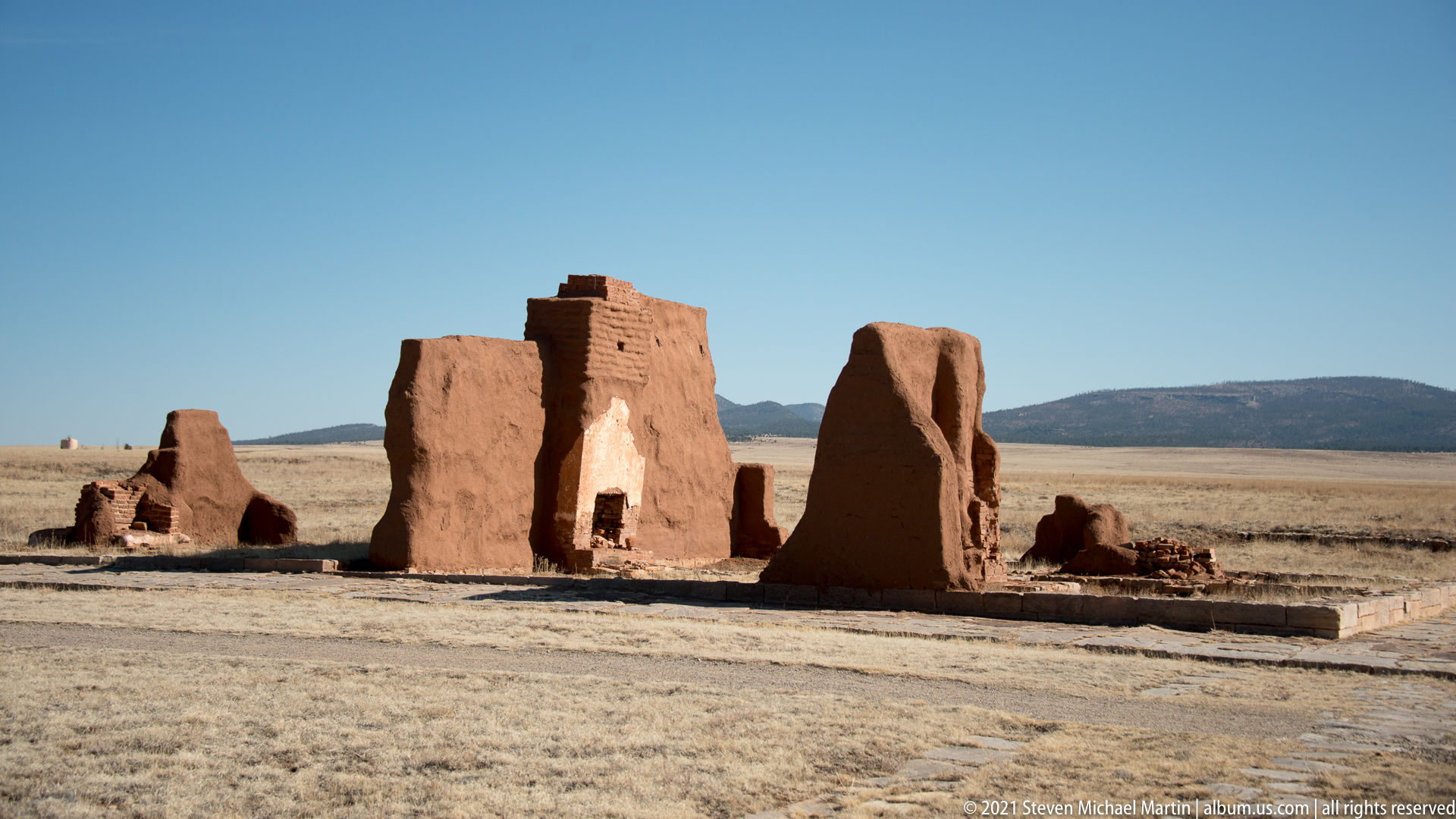
Several adobe wall fragments and taller wall sections rise from a flat grassy area beneath a wide, pale sky. Their varied heights trace the footprint of former rooms while leaving the interior spaces open to view. This angle favors the dispersed remnants and open ground between them, showing how the earthen architecture survives as partial walls rather than a continuous building.
Caption
Several adobe wall fragments and taller wall sections rise from a flat grassy area beneath a wide, pale sky. Their varied heights trace the footprint of former rooms while leaving the interior spaces open to view. This angle favors the dispersed remnants and open ground between them, showing how the earthen architecture survives as partial walls rather than a continuous building.

A broad adobe wall fragment dominates the foreground, its uneven top and weathered surface making the thickness of the earthen construction visible. A small interpretive plaque is fixed near the base, while more ruin remains continue beyond it. The close foreground wall gives this view a more intimate scale than the surrounding landscape, with the plaque offering site context that is too small to read here.
Caption
A broad adobe wall fragment dominates the foreground, its uneven top and weathered surface making the thickness of the earthen construction visible. A small interpretive plaque is fixed near the base, while more ruin remains continue beyond it. The close foreground wall gives this view a more intimate scale than the surrounding landscape, with the plaque offering site context that is too small to read here.

A cluster of adobe wall and chimney remnants stands on low foundations, separated by patches of grass. The broken sections vary in height, allowing the chimney forms to rise above the lower wall lines and reveal the former buildings’ vertical structure. Seen against open sky, the surviving earthen shapes form a compact group rather than a continuous façade, with the foundations marking their spread across the site.
Caption
A cluster of adobe wall and chimney remnants stands on low foundations, separated by patches of grass. The broken sections vary in height, allowing the chimney forms to rise above the lower wall lines and reveal the former buildings’ vertical structure. Seen against open sky, the surviving earthen shapes form a compact group rather than a continuous façade, with the foundations marking their spread across the site.

A sign headed “Commandants” pairs historical portraits with photographs of a barracks-like building and explanatory text. The arrangement places individuals alongside the architecture associated with their post, presenting leadership as part of the fort’s institutional history. At this scale the heading and image types are visible, while smaller written details remain unreadable. The panel is a distinct human-centered pause among nearby views of surviving walls.
Caption
A sign headed “Commandants” pairs historical portraits with photographs of a barracks-like building and explanatory text. The arrangement places individuals alongside the architecture associated with their post, presenting leadership as part of the fort’s institutional history. At this scale the heading and image types are visible, while smaller written details remain unreadable. The panel is a distinct human-centered pause among nearby views of surviving walls.

A long, low building fills this archival black-and-white photograph, its repeated windows and extended roofline emphasizing the barracks’ length. The image is presented as a historical reproduction within the exhibit, allowing visitors to compare the former built environment with the surviving ruins outside. No date or photographer is legible in the view, so the caption identifies the subject and format without assigning a specific period.
Caption
A long, low building fills this archival black-and-white photograph, its repeated windows and extended roofline emphasizing the barracks’ length. The image is presented as a historical reproduction within the exhibit, allowing visitors to compare the former built environment with the surviving ruins outside. No date or photographer is legible in the view, so the caption identifies the subject and format without assigning a specific period.

This archival interior photograph shows a furnished room with several people gathered near tables and chairs. A large window brightens the back of the space, while the arrangement of furniture gives the room a lived-in, functional character. The image provides a human-scale counterpoint to the architectural exteriors elsewhere in the exhibit. The individuals and precise room use cannot be identified from the reproduction.
Caption
This archival interior photograph shows a furnished room with several people gathered near tables and chairs. A large window brightens the back of the space, while the arrangement of furniture gives the room a lived-in, functional character. The image provides a human-scale counterpoint to the architectural exteriors elsewhere in the exhibit. The individuals and precise room use cannot be identified from the reproduction.

A field cannon stands prominently on the open ground before a long masonry building, its barrel and carriage set against the structure’s repeated openings. The composition places artillery in the foreground and built military architecture behind it, connecting equipment with the fort’s physical setting. The visible wall combines pale stone and reddish brick, while the low horizon keeps both cannon and building clearly outlined.
Caption
A field cannon stands prominently on the open ground before a long masonry building, its barrel and carriage set against the structure’s repeated openings. The composition places artillery in the foreground and built military architecture behind it, connecting equipment with the fort’s physical setting. The visible wall combines pale stone and reddish brick, while the low horizon keeps both cannon and building clearly outlined.

The panel “Rank Has Its Privileges” uses a cutaway plan to explain the arrangement of officers’ quarters. Its diagram exposes interior rooms that an exterior view would conceal, while surrounding text interprets distinctions in military housing. The title and plan are legible, but smaller details are not reliably readable from this reproduction. The exhibit turns architectural layout into evidence of rank and differentiated living space at the post.
Caption
The panel “Rank Has Its Privileges” uses a cutaway plan to explain the arrangement of officers’ quarters. Its diagram exposes interior rooms that an exterior view would conceal, while surrounding text interprets distinctions in military housing. The title and plan are legible, but smaller details are not reliably readable from this reproduction. The exhibit turns architectural layout into evidence of rank and differentiated living space at the post.

A long line of adobe wall remains and foundations crosses the middle distance, with a walking path entering from the right foreground. The broad framing gives the ruins room to read as a connected footprint rather than a collection of separate fragments. Low grass covers the open ground between path and walls, and the modest height of the remains leaves the horizon largely unobstructed.
Caption
A long line of adobe wall remains and foundations crosses the middle distance, with a walking path entering from the right foreground. The broad framing gives the ruins room to read as a connected footprint rather than a collection of separate fragments. Low grass covers the open ground between path and walls, and the modest height of the remains leaves the horizon largely unobstructed.

A large interpretive panel presents a plan of the Fort Union compound alongside blocks of explanatory text. The diagram organizes the site as a network of buildings and open spaces, offering a spatial overview rather than a view of any single ruin. Smaller labels are not legible at this distance, so the caption stays with the map’s clear function and overall subject.
Caption
A large interpretive panel presents a plan of the Fort Union compound alongside blocks of explanatory text. The diagram organizes the site as a network of buildings and open spaces, offering a spatial overview rather than a view of any single ruin. Smaller labels are not legible at this distance, so the caption stays with the map’s clear function and overall subject.

Seen from the front, the cannon’s dark muzzle is centered between its large wheels, which create a near-symmetrical frame. Adobe ruins and a low chimney stack remain visible behind the carriage, tying the close object view to the surrounding historic site. The frontal angle makes the cannon’s circular bore and broad stance more prominent than in the wider landscape views elsewhere in the batch.
Caption
Seen from the front, the cannon’s dark muzzle is centered between its large wheels, which create a near-symmetrical frame. Adobe ruins and a low chimney stack remain visible behind the carriage, tying the close object view to the surrounding historic site. The frontal angle makes the cannon’s circular bore and broad stance more prominent than in the wider landscape views elsewhere in the batch.

Two visitors move along a path beside the low adobe remains, providing a human scale for the broad, open ruin field. Their figures are small in the composition, while the long earthen wall line extends across the background. The view records a present-day encounter with the site without making assumptions about the visitors or their activity beyond walking along the route.
Caption
Two visitors move along a path beside the low adobe remains, providing a human scale for the broad, open ruin field. Their figures are small in the composition, while the long earthen wall line extends across the background. The view records a present-day encounter with the site without making assumptions about the visitors or their activity beyond walking along the route.

A clump of spiky yucca and coarse grass fills the foreground, while low adobe ruins form a distant horizontal line across the plain. The separation between near vegetation and far architecture gives this view unusual depth, placing the remains within the open New Mexico grassland rather than isolating them as a close subject. The sparse landscape and broad sky make the fort’s low profile especially apparent.
Caption
A clump of spiky yucca and coarse grass fills the foreground, while low adobe ruins form a distant horizontal line across the plain. The separation between near vegetation and far architecture gives this view unusual depth, placing the remains within the open New Mexico grassland rather than isolating them as a close subject. The sparse landscape and broad sky make the fort’s low profile especially apparent.

The panel “The Arsenal: Distant for Good Reasons” pairs a site map with explanatory text and a small flag illustration. The mapped buildings situate the arsenal within the wider fort grounds, while the heading signals the exhibit’s focus on its separation from other structures. Fine labels cannot be read at this scale, so the caption describes the visible title and map without adding details about the arsenal’s layout.
Caption
The panel “The Arsenal: Distant for Good Reasons” pairs a site map with explanatory text and a small flag illustration. The mapped buildings situate the arsenal within the wider fort grounds, while the heading signals the exhibit’s focus on its separation from other structures. Fine labels cannot be read at this scale, so the caption describes the visible title and map without adding details about the arsenal’s layout.

A panel titled “Buttons, Bowling, Billiards, and Beer” presents historical material about social life at the post. An archival image and blocks of text accompany the heading, shifting the subject from military structures and discipline to recreation and daily routines. The smaller writing is not legible here, so the caption identifies only the clear theme and the exhibit’s visible combination of text and historic imagery.
Caption
A panel titled “Buttons, Bowling, Billiards, and Beer” presents historical material about social life at the post. An archival image and blocks of text accompany the heading, shifting the subject from military structures and discipline to recreation and daily routines. The smaller writing is not legible here, so the caption identifies only the clear theme and the exhibit’s visible combination of text and historic imagery.

A dark doorway cuts through an eroded adobe wall, its opening edged with exposed brick that contrasts with the softened earthen surface. The close frontal angle reveals the uneven wall texture and the doorway’s rectangular outline more clearly than the broad ruin views. No door remains in the opening; the empty threshold makes the thickness and weathering of the surviving wall the focus.
Caption
A dark doorway cuts through an eroded adobe wall, its opening edged with exposed brick that contrasts with the softened earthen surface. The close frontal angle reveals the uneven wall texture and the doorway’s rectangular outline more clearly than the broad ruin views. No door remains in the opening; the empty threshold makes the thickness and weathering of the surviving wall the focus.

Two brick-framed doorways punctuate separate adobe wall sections, with a lower wall fragment connecting or dividing the structures. The paired openings create a repeated architectural rhythm across the foreground, while the surrounding walls show uneven tops and exposed earthen surfaces. This view emphasizes the sequence of openings and the surviving room divisions rather than the isolated doorway detail seen elsewhere.
Caption
Two brick-framed doorways punctuate separate adobe wall sections, with a lower wall fragment connecting or dividing the structures. The paired openings create a repeated architectural rhythm across the foreground, while the surrounding walls show uneven tops and exposed earthen surfaces. This view emphasizes the sequence of openings and the surviving room divisions rather than the isolated doorway detail seen elsewhere.

Two low adobe structures stand in a sunlit clearing, their rounded, eroded walls rising above brick-lined rectangular openings. The nearer doorway frames a dark interior, while a second opening sits farther back between thick earthen walls. The composition emphasizes the contrast between rough adobe masses and the regular courses of brick around the entrances.
Caption
Two low adobe structures stand in a sunlit clearing, their rounded, eroded walls rising above brick-lined rectangular openings. The nearer doorway frames a dark interior, while a second opening sits farther back between thick earthen walls. The composition emphasizes the contrast between rough adobe masses and the regular courses of brick around the entrances.

The reverse side of the same pale stone pedestal presents a broad, largely undecorated panel beneath a projecting cap. Two dark metal fittings and a faint diagonal line mark the otherwise plain surface. Direct sunlight sharpens the shallow recess and the rough stone grain, while dry grass and a saturated blue sky place the object outdoors at Fort Union.
Caption
The reverse side of the same pale stone pedestal presents a broad, largely undecorated panel beneath a projecting cap. Two dark metal fittings and a faint diagonal line mark the otherwise plain surface. Direct sunlight sharpens the shallow recess and the rough stone grain, while dry grass and a saturated blue sky place the object outdoors at Fort Union.

Seen from a low three-quarter angle, the stone pedestal reveals its stepped base, inset dial face, and a small dark triangular element resting on top. The view clarifies the object’s block-like construction and placement on open ground; the adobe ruins of Fort Union sit softly out of focus across the background.
Caption
Seen from a low three-quarter angle, the stone pedestal reveals its stepped base, inset dial face, and a small dark triangular element resting on top. The view clarifies the object’s block-like construction and placement on open ground; the adobe ruins of Fort Union sit softly out of focus across the background.

A close, nearly level view isolates two narrow openings in a massive adobe wall. Weathered horizontal timbers span each aperture, and the lower opening is partly filled by a rough earthen surface. The unadorned wall and minimal slice of blue sky draw attention to practical construction details and the deep shadow beneath the upper lintel.
Caption
A close, nearly level view isolates two narrow openings in a massive adobe wall. Weathered horizontal timbers span each aperture, and the lower opening is partly filled by a rough earthen surface. The unadorned wall and minimal slice of blue sky draw attention to practical construction details and the deep shadow beneath the upper lintel.

A narrow courtyard opens between tall adobe walls, with several brick-edged doorways arranged at different depths. Strong afternoon light falls across the central ground while the left wall casts a sharply defined shadow. The irregular wall tops and small high openings reveal the weathered condition of the surviving structures, and the converging passage gives the ruin a distinctly enclosed scale.
Caption
A narrow courtyard opens between tall adobe walls, with several brick-edged doorways arranged at different depths. Strong afternoon light falls across the central ground while the left wall casts a sharply defined shadow. The irregular wall tops and small high openings reveal the weathered condition of the surviving structures, and the converging passage gives the ruin a distinctly enclosed scale.

An interpretive panel titled “A Business for New Mexico” combines a historic building photograph, a uniformed figure, a route map, and explanatory text. The broad layout connects Fort Union with regional commerce and transportation rather than presenting a single artifact. Its pale blue background and layered images make the exhibit’s synthesis visible, though most small print is too fine to read at this distance.
Caption
An interpretive panel titled “A Business for New Mexico” combines a historic building photograph, a uniformed figure, a route map, and explanatory text. The broad layout connects Fort Union with regional commerce and transportation rather than presenting a single artifact. Its pale blue background and layered images make the exhibit’s synthesis visible, though most small print is too fine to read at this distance.

An illustrated site plan shows the quartermaster depot as a dense arrangement of labeled buildings, yards, and service areas. Text panels frame the drawing, while a “You Are Here” marker anchors the diagram to the visitor’s location. The oblique camera angle and reflections soften some lettering, but the plan clearly communicates the scale and organization of the former supply complex.
Caption
An illustrated site plan shows the quartermaster depot as a dense arrangement of labeled buildings, yards, and service areas. Text panels frame the drawing, while a “You Are Here” marker anchors the diagram to the visitor’s location. The oblique camera angle and reflections soften some lettering, but the plan clearly communicates the scale and organization of the former supply complex.

A historical illustration depicts civilian workers and soldiers moving barrels and supplies through a sequence of open storehouse doors. Repeated doorframes create a deep perspective, while a shipment list and explanatory text surround the scene. The panel’s title, “Enough to Feed an Army,” frames the loading activity as part of the depot’s logistical role; the image itself centers on the people, goods, and architecture.
Caption
A historical illustration depicts civilian workers and soldiers moving barrels and supplies through a sequence of open storehouse doors. Repeated doorframes create a deep perspective, while a shipment list and explanatory text surround the scene. The panel’s title, “Enough to Feed an Army,” frames the loading activity as part of the depot’s logistical role; the image itself centers on the people, goods, and architecture.

Two wooden wagons stand among low adobe remnants in an open, dry field. A tall, irregular earthen wall fragment rises in the foreground, partially obscuring the central view; a second wagon sits farther right, and more ruins recede behind it. The strong midday light exposes the wagons’ spoked wheels and the broken outlines of the structures against the flat grassland.
Caption
Two wooden wagons stand among low adobe remnants in an open, dry field. A tall, irregular earthen wall fragment rises in the foreground, partially obscuring the central view; a second wagon sits farther right, and more ruins recede behind it. The strong midday light exposes the wagons’ spoked wheels and the broken outlines of the structures against the flat grassland.

A weathered wagon stands just inside a broad adobe wall, aligned with a rounded gateway that opens onto the grassland beyond. One detached wheel leans against the wall, while the wagon’s high wooden sides and spoked wheels sit in deep shade. The framing uses the gateway as both passage and architectural subject, showing how the surviving wall encloses the transport scene.
Caption
A weathered wagon stands just inside a broad adobe wall, aligned with a rounded gateway that opens onto the grassland beyond. One detached wheel leans against the wall, while the wagon’s high wooden sides and spoked wheels sit in deep shade. The framing uses the gateway as both passage and architectural subject, showing how the surviving wall encloses the transport scene.

A wide interpretive panel titled “Keep the Wagons Rolling” depicts mechanics working on wagons in a courtyard. Men handle timber and tools among carts, barrels, and workshop buildings, while text explains the repair work carried out at the post. The illustrated scene makes maintenance labor central, distinguishing this exhibit from panels devoted to storage, mapping, or transportation routes.
Caption
A wide interpretive panel titled “Keep the Wagons Rolling” depicts mechanics working on wagons in a courtyard. Men handle timber and tools among carts, barrels, and workshop buildings, while text explains the repair work carried out at the post. The illustrated scene makes maintenance labor central, distinguishing this exhibit from panels devoted to storage, mapping, or transportation routes.

Several wooden wagons are arranged across an open yard bordered by low adobe walls with rectangular openings. The nearest vehicle is reduced to its exposed wheels, axle, and long shafts, while two box-bodied wagons stand farther back. Their different forms are easy to compare against the bare ground and broken architecture, giving this broad view the feel of an outdoor transport display.
Caption
Several wooden wagons are arranged across an open yard bordered by low adobe walls with rectangular openings. The nearest vehicle is reduced to its exposed wheels, axle, and long shafts, while two box-bodied wagons stand farther back. Their different forms are easy to compare against the bare ground and broken architecture, giving this broad view the feel of an outdoor transport display.

A curly-coated brown dog sits upright on a low metal platform, facing slightly left of the camera. Its green harness and alert expression stand out against the sunlit adobe buildings behind it. The low viewpoint brings the animal forward while repeated wall openings and the open grassland establish the setting; the photograph is a portrait of a visitor’s companion at the historic site.
Caption
A curly-coated brown dog sits upright on a low metal platform, facing slightly left of the camera. Its green harness and alert expression stand out against the sunlit adobe buildings behind it. The low viewpoint brings the animal forward while repeated wall openings and the open grassland establish the setting; the photograph is a portrait of a visitor’s companion at the historic site.

The same curly-coated dog now raises its left forepaw while standing on the metal platform, its head turned toward the camera. The gesture and direct eye contact give this frame a more animated pose than the neighboring seated portrait. Behind the animal, the long adobe wall recedes across the dry ground, keeping the historic site recognizable without competing with the foreground subject.
Caption
The same curly-coated dog now raises its left forepaw while standing on the metal platform, its head turned toward the camera. The gesture and direct eye contact give this frame a more animated pose than the neighboring seated portrait. Behind the animal, the long adobe wall recedes across the dry ground, keeping the historic site recognizable without competing with the foreground subject.

An interpretive panel titled “Hard Work, Strict Discipline, and $13 a Month” pairs a drawing of enlisted men’s barracks with a historical figure and blocks of explanatory text. The floor plan reveals rows of rooms around open courtyards, while small illustrated people suggest daily activity within the complex. The exhibit presents military living quarters as an organized residential environment rather than a single architectural façade.
Caption
An interpretive panel titled “Hard Work, Strict Discipline, and $13 a Month” pairs a drawing of enlisted men’s barracks with a historical figure and blocks of explanatory text. The floor plan reveals rows of rooms around open courtyards, while small illustrated people suggest daily activity within the complex. The exhibit presents military living quarters as an organized residential environment rather than a single architectural façade.

A visitor walks a leashed dog along a paved path through the open grounds, with adobe ruins spread across the background. The person and animal appear small within the broad grassland and scattered structures, making the site’s scale the dominant impression. A tall adobe remnant anchors the left side, while a flagpole and distant tree line mark the horizon beneath a clear sky.
Caption
A visitor walks a leashed dog along a paved path through the open grounds, with adobe ruins spread across the background. The person and animal appear small within the broad grassland and scattered structures, making the site’s scale the dominant impression. A tall adobe remnant anchors the left side, while a flagpole and distant tree line mark the horizon beneath a clear sky.

An aerial photograph reproduced on an interpretive panel shows the geometric footprint of Fort Union within a dry, open landscape. Rectangular compounds and earth-colored traces are visible from above, while a block of text at right is headed “The Santa Fe Trail.” The image connects the fort’s built layout with its wider route setting, though the photograph is mediated by the exhibit surface and its explanatory text.
Caption
An aerial photograph reproduced on an interpretive panel shows the geometric footprint of Fort Union within a dry, open landscape. Rectangular compounds and earth-colored traces are visible from above, while a block of text at right is headed “The Santa Fe Trail.” The image connects the fort’s built layout with its wider route setting, though the photograph is mediated by the exhibit surface and its explanatory text.

A long roofless adobe building extends across the grassland, its sequence of rooms and doorway openings exposed to view. Dark timber braces support several weakened wall sections, and the broken roofline varies in height from one room to the next. Photographed from a distance, the structure reads as a continuous barracks range, with its scale and ongoing stabilization visible across the full façade.
Caption
A long roofless adobe building extends across the grassland, its sequence of rooms and doorway openings exposed to view. Dark timber braces support several weakened wall sections, and the broken roofline varies in height from one room to the next. Photographed from a distance, the structure reads as a continuous barracks range, with its scale and ongoing stabilization visible across the full façade.
Fort Union National Monument — Field Guide
National Monument Field Guide
📍 Overview
Fort Union National Monument preserves the remains of a major military and supply post associated with the Santa Fe Trail and the nineteenth-century expansion of transportation networks across the Southwest. Established in northeastern New Mexico, the fort supported trade, travel, and military operations in a region where geography strongly influenced movement and settlement. The site reflects the practical realities of frontier infrastructure in an open grassland environment.
Adobe ruins mark the layout of the post and provide insight into the scale of military and logistical operations once carried out here. The fort’s location along important overland routes illustrates its strategic function in supporting commerce and federal presence across the region. The surrounding landscape reinforces the fort’s connection to long-distance travel and regional development.
⭐ Highlights
- Adobe ruins of a major frontier military post
- Strong connection to the Santa Fe Trail
- Open grassland setting with broad views
- Interpretation of trade and military logistics
- Historic landscape illustrating overland travel routes
🔎 Key Features
- Ruins preserving the fort’s original layout
- Adobe construction adapted to regional conditions
- Strategic location along transportation corridors
- Context for military support of frontier travel
- Landscape emphasizing the scale of regional movement
📷 Photography Notes
- Low-angle light brings out texture in adobe walls
- Wide framing helps show the fort within the plains
- Simple compositions work well with low ruins and open sky
- Cloud shadows can add depth to the landscape
- Look for lines in walls and pathways for structure
- Evening light often creates a warm tone on adobe surfaces