Colorado National Monument
Colorado National Monument preserves a dramatic landscape of red sandstone canyons, towering monoliths, and high desert plateaus shaped by erosion acting upon uplifted sedimentary rock layers. Located along the edge of the Colorado Plateau, the monument illustrates the transition between canyon environments and elevated desert terrain. The exposed rock formations reveal geological processes that have shaped the region over millions of years.
Deep canyon corridors cut through layers of Wingate sandstone and other sedimentary formations deposited during prehistoric eras. Differential erosion has produced spires, fins, and cliff faces that display variations in color and texture influenced by mineral composition. The monument demonstrates how tectonic uplift and weathering interact to produce visually distinctive landforms.
Visitors encounter sweeping views across canyon systems and plateau landscapes that emphasize the scale of geological forces operating across the region. The monument provides an introduction to the broader geological character of the Colorado Plateau and the processes that shaped many of the sites included in this itinerary.

Rows of small hay bales pattern a broad green field in the foreground, bounded by fence posts and low vegetation. Beyond the field, a line of rugged mountains stretches beneath a sky filled with large, bright clouds. The distant ridgeline and cultivated valley floor establish a rural setting outside the monument’s more enclosed canyon landscapes.
Caption
Rows of small hay bales pattern a broad green field in the foreground, bounded by fence posts and low vegetation. Beyond the field, a line of rugged mountains stretches beneath a sky filled with large, bright clouds. The distant ridgeline and cultivated valley floor establish a rural setting outside the monument’s more enclosed canyon landscapes.

A closer view brings the harvested field into focus, where evenly scattered round hay bales rest in parallel strips of cut grass. Fence posts and wire cross the foreground, while cottonwood-like trees and pale foothills lead toward a higher mountain ridge. The orderly bales and field lines create a strong contrast with the irregular slopes beyond.
Caption
A closer view brings the harvested field into focus, where evenly scattered round hay bales rest in parallel strips of cut grass. Fence posts and wire cross the foreground, while cottonwood-like trees and pale foothills lead toward a higher mountain ridge. The orderly bales and field lines create a strong contrast with the irregular slopes beyond.

The view opens beyond a pale rocky rim to a broad valley patterned with fields, roads, scattered buildings, and a denser settlement near the center. A long mesa forms the distant horizon beneath a muted blue-gray sky. The expansive framing contrasts the sparsely vegetated foreground with the developed valley floor, situating the monument’s canyon country within its wider regional landscape.
Caption
The view opens beyond a pale rocky rim to a broad valley patterned with fields, roads, scattered buildings, and a denser settlement near the center. A long mesa forms the distant horizon beneath a muted blue-gray sky. The expansive framing contrasts the sparsely vegetated foreground with the developed valley floor, situating the monument’s canyon country within its wider regional landscape.

The highway threads along the foot of a steep, forested canyon, with a metal guardrail tracing the road above the river corridor. Layered rock faces rise behind dense evergreen cover, while a break in the clouds brightens the upper slope. The roadway’s placement makes the drive itself the foreground subject and shows how the route is confined by the canyon walls.
Caption
The highway threads along the foot of a steep, forested canyon, with a metal guardrail tracing the road above the river corridor. Layered rock faces rise behind dense evergreen cover, while a break in the clouds brightens the upper slope. The roadway’s placement makes the drive itself the foreground subject and shows how the route is confined by the canyon walls.

The river occupies the lower foreground before turning beneath a high, sunlit canyon wall streaked with horizontal strata. Shrubs and small trees line the water’s edge, while darker rock outcrops frame the right side of the view. This open vantage shifts attention away from the roadway to the river corridor and the varied textures of the canyon’s layered stone.
Caption
The river occupies the lower foreground before turning beneath a high, sunlit canyon wall streaked with horizontal strata. Shrubs and small trees line the water’s edge, while darker rock outcrops frame the right side of the view. This open vantage shifts attention away from the roadway to the river corridor and the varied textures of the canyon’s layered stone.

From a rocky overlook, the canyon opens into a wide arrangement of red and cream-colored ledges, gullies, and mesas. A rain shaft descends from heavy clouds in the distance, leaving the foreground scrub and pale rim rocks in changing light. The view emphasizes the scale and erosion patterns of the plateau, with scattered pinyon-juniper vegetation clinging to the slopes.
Caption
From a rocky overlook, the canyon opens into a wide arrangement of red and cream-colored ledges, gullies, and mesas. A rain shaft descends from heavy clouds in the distance, leaving the foreground scrub and pale rim rocks in changing light. The view emphasizes the scale and erosion patterns of the plateau, with scattered pinyon-juniper vegetation clinging to the slopes.

A broad, banded cliff spans the far side of the canyon, with a green river corridor winding below it. The opposing slopes carry a mix of shrubs and conifers, while a dark rock outcrop frames the right edge and adds depth to the scene. Clear midday light separates the pale, fractured lower slope from the darker horizontal ledges above.
Caption
A broad, banded cliff spans the far side of the canyon, with a green river corridor winding below it. The opposing slopes carry a mix of shrubs and conifers, while a dark rock outcrop frames the right edge and adds depth to the scene. Clear midday light separates the pale, fractured lower slope from the darker horizontal ledges above.

A yellow diamond warning sign with a black bighorn sheep silhouette stands above a second panel reading “Bighorn Sheep Crossing Next 23 Miles.” The sharply legible sign is set against blurred red rock and scrub, making wildlife movement the subject even though no animal appears. Its specific distance gives the notice a practical, route-based emphasis for drivers traveling through the area.
Caption
A yellow diamond warning sign with a black bighorn sheep silhouette stands above a second panel reading “Bighorn Sheep Crossing Next 23 Miles.” The sharply legible sign is set against blurred red rock and scrub, making wildlife movement the subject even though no animal appears. Its specific distance gives the notice a practical, route-based emphasis for drivers traveling through the area.

A broad canyon wall dominates this view, its horizontal rock bands partly screened by dark conifers and scattered shrubs. The highway hugs the lower edge of the slope, with several vehicles visible near the right side and a guardrail marking the drop toward the river corridor. Compared with the preceding view, the frame gives more space to the cliff’s scale and the dense vegetation covering its upper rim.
Caption
A broad canyon wall dominates this view, its horizontal rock bands partly screened by dark conifers and scattered shrubs. The highway hugs the lower edge of the slope, with several vehicles visible near the right side and a guardrail marking the drop toward the river corridor. Compared with the preceding view, the frame gives more space to the cliff’s scale and the dense vegetation covering its upper rim.

A dark, rounded tunnel mouth interrupts the sunlit roadway as it passes between towering canyon walls. A vehicle approaches the opening, while the road’s yellow center line and concrete barrier lead the eye into the confined passage. The composition contrasts the smooth engineered tunnel portal with the rough, stratified rock enclosing it, recording a dramatic transition along the canyon drive.
Caption
A dark, rounded tunnel mouth interrupts the sunlit roadway as it passes between towering canyon walls. A vehicle approaches the opening, while the road’s yellow center line and concrete barrier lead the eye into the confined passage. The composition contrasts the smooth engineered tunnel portal with the rough, stratified rock enclosing it, recording a dramatic transition along the canyon drive.

Seen from below, blocky sandstone walls rise on both sides of a narrow canyon, their ledges and fractures catching warm light. Green shrubs and small trees fill the rocky lower slope, softening the boundary between the exposed stone and the roadway corridor. Thin utility lines cross the scene, a subtle sign of infrastructure within this otherwise rugged canyon setting.
Caption
Seen from below, blocky sandstone walls rise on both sides of a narrow canyon, their ledges and fractures catching warm light. Green shrubs and small trees fill the rocky lower slope, softening the boundary between the exposed stone and the roadway corridor. Thin utility lines cross the scene, a subtle sign of infrastructure within this otherwise rugged canyon setting.

The highway bends around a close rock face while a river appears below the guardrail on the opposite side of the canyon. A tunnel portal and a few vehicles recede around the curve, linking the road to the narrow river corridor. Bright midday light picks out the pale stone and green vegetation, while the vertical walls emphasize how closely the route follows the canyon’s contours.
Caption
The highway bends around a close rock face while a river appears below the guardrail on the opposite side of the canyon. A tunnel portal and a few vehicles recede around the curve, linking the road to the narrow river corridor. Bright midday light picks out the pale stone and green vegetation, while the vertical walls emphasize how closely the route follows the canyon’s contours.

A printed recreation map fills the frame with shaded relief, colored boundary lines, road routes, and a trail inset labeled for the Rattlesnake Arches Trail. A “You Are Here” marker and map legend situate the sheet as an orientation aid rather than a landscape view. The map’s fine labels and symbols record how visitors navigate the surrounding public lands and designated recreation areas.
Caption
A printed recreation map fills the frame with shaded relief, colored boundary lines, road routes, and a trail inset labeled for the Rattlesnake Arches Trail. A “You Are Here” marker and map legend situate the sheet as an orientation aid rather than a landscape view. The map’s fine labels and symbols record how visitors navigate the surrounding public lands and designated recreation areas.

This tighter panorama centers the canyon’s nested red-rock ledges and pale, scrub-covered slopes beneath a low band of rain. Dark storm clouds gather over the horizon while the foreground rim remains sunlit, creating a sharp shift in atmosphere across the landform. The compressed viewpoint makes the stepped strata and branching drainage channels more prominent than the distant skyline.
Caption
This tighter panorama centers the canyon’s nested red-rock ledges and pale, scrub-covered slopes beneath a low band of rain. Dark storm clouds gather over the horizon while the foreground rim remains sunlit, creating a sharp shift in atmosphere across the landform. The compressed viewpoint makes the stepped strata and branching drainage channels more prominent than the distant skyline.

The expansive canyon view reveals a patchwork of red cliffs, pale benches, and green scrub extending toward a flat horizon. A vertical curtain of rain falls beneath the cloud bank near the center, while a brighter opening remains at the far left. From this elevated vantage, the photograph records both the region’s eroded plateau structure and rapidly changing weather.
Caption
The expansive canyon view reveals a patchwork of red cliffs, pale benches, and green scrub extending toward a flat horizon. A vertical curtain of rain falls beneath the cloud bank near the center, while a brighter opening remains at the far left. From this elevated vantage, the photograph records both the region’s eroded plateau structure and rapidly changing weather.

A large, tilted boulder rises beside the highway as the road approaches a junction marked by stop and directional signs. Low sage-colored shrubs surround the rock, and dark storm clouds gather over the distant landscape. The roadside formation dominates the left foreground, turning an ordinary intersection into a striking encounter between the route and the surrounding exposed geology.
Caption
A large, tilted boulder rises beside the highway as the road approaches a junction marked by stop and directional signs. Low sage-colored shrubs surround the rock, and dark storm clouds gather over the distant landscape. The roadside formation dominates the left foreground, turning an ordinary intersection into a striking encounter between the route and the surrounding exposed geology.

A rugged foreground of reddish ledges and scrub opens toward a pale, horizontally banded mesa in the distance. Heavy clouds still cover much of the sky, though a brighter break appears along the far horizon. The alternating rock colors and stepped slopes reveal the canyon’s layered geology, while the broad composition balances near cliffs against the more distant plateau.
Caption
A rugged foreground of reddish ledges and scrub opens toward a pale, horizontally banded mesa in the distance. Heavy clouds still cover much of the sky, though a brighter break appears along the far horizon. The alternating rock colors and stepped slopes reveal the canyon’s layered geology, while the broad composition balances near cliffs against the more distant plateau.

A pale, flat-topped mesa anchors the middle distance, surrounded by rust-colored cliffs and a broad foreground of low shrubs. The cloud cover is thick, but diffuse light reveals the distinct horizontal bands across the slopes. This view isolates the mesa more clearly than the neighboring panorama, setting its light-colored layers against the darker red canyon walls.
Caption
A pale, flat-topped mesa anchors the middle distance, surrounded by rust-colored cliffs and a broad foreground of low shrubs. The cloud cover is thick, but diffuse light reveals the distinct horizontal bands across the slopes. This view isolates the mesa more clearly than the neighboring panorama, setting its light-colored layers against the darker red canyon walls.

A two-lane road sweeps around a tall, narrow sandstone fin that rises close to the shoulder like a natural roadside marker. The yellow center lines guide the curve beneath layered red cliffs, while scattered shrubs and boulders cover the slope. The viewpoint places the fin prominently in the foreground and shows how the road winds through a tight passage in the rock terrain.
Caption
A two-lane road sweeps around a tall, narrow sandstone fin that rises close to the shoulder like a natural roadside marker. The yellow center lines guide the curve beneath layered red cliffs, while scattered shrubs and boulders cover the slope. The viewpoint places the fin prominently in the foreground and shows how the road winds through a tight passage in the rock terrain.

A rough footpath descends between pale boulders and low juniper toward the canyon floor, where a section of road is visible at the far left. Layered red and cream cliffs fill the background beneath a clearing sky. This elevated view connects the monument’s walkable rocky terrain with the road corridor below, while foreground stones give the slope a close, tactile scale.
Caption
A rough footpath descends between pale boulders and low juniper toward the canyon floor, where a section of road is visible at the far left. Layered red and cream cliffs fill the background beneath a clearing sky. This elevated view connects the monument’s walkable rocky terrain with the road corridor below, while foreground stones give the slope a close, tactile scale.

A deep valley recedes between a dark red cliff on the left and an expansive pale, banded mesa beyond. Sparse shrubs cover the lower slopes, and a break in the clouds casts brighter light across the distant formations. The framing cliff gives the view a strong sense of enclosure while drawing attention toward the changing colors and elevations in the canyon interior.
Caption
A deep valley recedes between a dark red cliff on the left and an expansive pale, banded mesa beyond. Sparse shrubs cover the lower slopes, and a break in the clouds casts brighter light across the distant formations. The framing cliff gives the view a strong sense of enclosure while drawing attention toward the changing colors and elevations in the canyon interior.

A small vehicle rounds the highway below towering sandstone walls, with an arched recess and horizontal strata visible in the cliff face. The road curves across the lower frame, bordered by desert shrubs and a roadside sign. The scale of the car against the rock makes the narrow corridor legible and emphasizes the close relationship between the engineered route and the canyon terrain.
Caption
A small vehicle rounds the highway below towering sandstone walls, with an arched recess and horizontal strata visible in the cliff face. The road curves across the lower frame, bordered by desert shrubs and a roadside sign. The scale of the car against the rock makes the narrow corridor legible and emphasizes the close relationship between the engineered route and the canyon terrain.

The highway points directly toward a narrow passage where two tall, weathered sandstone fins stand close to the road. Double yellow lines converge toward the gap, while the reddish walls show horizontal bedding and worn, rounded edges. The nearly frontal viewpoint gives the rock corridor a gateway-like form without obscuring that it is a natural opening beside the paved route.
Caption
The highway points directly toward a narrow passage where two tall, weathered sandstone fins stand close to the road. Double yellow lines converge toward the gap, while the reddish walls show horizontal bedding and worn, rounded edges. The nearly frontal viewpoint gives the rock corridor a gateway-like form without obscuring that it is a natural opening beside the paved route.

A broad hairpin bend curls across the lower slope, its guardrail tracing the curve beneath a long wall of horizontally banded sandstone. Sparse shrubs and pale boulders occupy the inner shoulder, while a distant blue ridge appears beyond the canyon. This elevated angle makes the roadway’s tight geometry and its careful fit along the steep terrain the defining features.
Caption
A broad hairpin bend curls across the lower slope, its guardrail tracing the curve beneath a long wall of horizontally banded sandstone. Sparse shrubs and pale boulders occupy the inner shoulder, while a distant blue ridge appears beyond the canyon. This elevated angle makes the roadway’s tight geometry and its careful fit along the steep terrain the defining features.

Rock walls close in at both edges to frame a distant pale mesa and the green, shrub-covered canyon below. Storm clouds hang over the ridge, while a bright patch of light falls across the far formations. The foreground rocks create a natural window onto the expansive valley, giving this view a more enclosed perspective than the open overlooks elsewhere in the sequence.
Caption
Rock walls close in at both edges to frame a distant pale mesa and the green, shrub-covered canyon below. Storm clouds hang over the ridge, while a bright patch of light falls across the far formations. The foreground rocks create a natural window onto the expansive valley, giving this view a more enclosed perspective than the open overlooks elsewhere in the sequence.
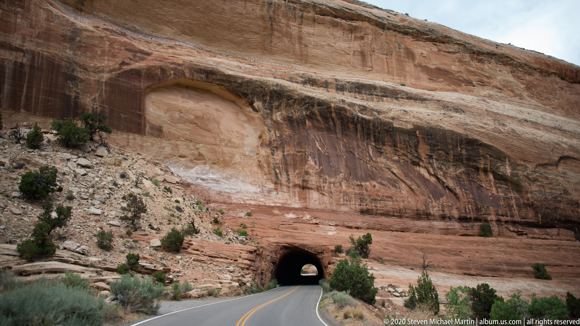
A paved road climbs toward a dark tunnel opening cut through the base of a broad sandstone wall. The rock above forms a shallow arch-like recess, with horizontal bands and darker mineral streaks running across the face. Desert shrubs and loose stone border the road, whose yellow center line leads directly into the passage.
Caption
A paved road climbs toward a dark tunnel opening cut through the base of a broad sandstone wall. The rock above forms a shallow arch-like recess, with horizontal bands and darker mineral streaks running across the face. Desert shrubs and loose stone border the road, whose yellow center line leads directly into the passage.

The tunnel portal sits low in a sweeping sandstone face, reached by a road that bends gently across the foreground. A large shallow recess above the entrance and dark vertical streaks reveal varied weathering across the wall. Compared with the previous view, this frame leaves more roadway visible and places the tunnel farther back, clarifying the approach through the canyon.
Caption
The tunnel portal sits low in a sweeping sandstone face, reached by a road that bends gently across the foreground. A large shallow recess above the entrance and dark vertical streaks reveal varied weathering across the wall. Compared with the previous view, this frame leaves more roadway visible and places the tunnel farther back, clarifying the approach through the canyon.

From a high rocky viewpoint, the canyon drops through bands of red and pale stone toward a road curling around the slope at right. The road appears small against the broad valley, while juniper and scrub cling to the nearer cliffs. A distant blue ridge and storm clouds complete the layered view, linking the route below to the expansive canyon landform.
Caption
From a high rocky viewpoint, the canyon drops through bands of red and pale stone toward a road curling around the slope at right. The road appears small against the broad valley, while juniper and scrub cling to the nearer cliffs. A distant blue ridge and storm clouds complete the layered view, linking the route below to the expansive canyon landform.

A rough, pale sandstone outcrop fills the right foreground, its pitted surfaces and angular blocks sharply visible above a hairpin bend in the road. Across the valley, layered red cliffs and a pale mesa recede into the distance. The close rock texture contrasts with the small vehicle and curved roadway below, making the overlook’s height and geological detail central to the composition.
Caption
A rough, pale sandstone outcrop fills the right foreground, its pitted surfaces and angular blocks sharply visible above a hairpin bend in the road. Across the valley, layered red cliffs and a pale mesa recede into the distance. The close rock texture contrasts with the small vehicle and curved roadway below, making the overlook’s height and geological detail central to the composition.

A small juniper grows beside pale sandstone slabs whose thin horizontal layers have fractured and weathered into shallow ledges. A rounded cavity punctures one slab near the ground, while loose stones and grasses fill the gaps. The close view draws attention to the interaction of hardy vegetation and exposed rock, shifting from distant canyon scenery to a specific detail of the slope.
Caption
A small juniper grows beside pale sandstone slabs whose thin horizontal layers have fractured and weathered into shallow ledges. A rounded cavity punctures one slab near the ground, while loose stones and grasses fill the gaps. The close view draws attention to the interaction of hardy vegetation and exposed rock, shifting from distant canyon scenery to a specific detail of the slope.

A layered, pale sandstone ledge drops away at left, its broken shelves dotted with low junipers. Beyond the rim, a broad valley contains clusters of buildings, roads, and open land, with a long mesa-lined horizon beneath scattered clouds. The elevated viewpoint connects the monument’s exposed rock edge to the settled landscape below without assigning an unverified place name.
Caption
A layered, pale sandstone ledge drops away at left, its broken shelves dotted with low junipers. Beyond the rim, a broad valley contains clusters of buildings, roads, and open land, with a long mesa-lined horizon beneath scattered clouds. The elevated viewpoint connects the monument’s exposed rock edge to the settled landscape below without assigning an unverified place name.
Colorado National Monument — Field Guide
National Monument Field Guide
📍 Overview
Colorado National Monument preserves a high desert landscape of sandstone cliffs, deep canyons, and monolithic rock formations shaped by erosion acting upon uplifted sedimentary rock layers. The monument illustrates the geological processes that formed the canyon environments characteristic of the Colorado Plateau. Wind and water erosion continue to influence the appearance of the landscape.
Layered rock formations reveal variations in deposition across prehistoric eras, while tectonic uplift exposed sedimentary strata to weathering. The monument demonstrates the relationship between geological structure and long-term erosion that produces cliffs, fins, and canyon corridors.
⭐ Highlights
- Sandstone monoliths rising above canyon floors
- Deep canyon corridors shaped by erosion
- Layered sedimentary rock exposures
- High desert plateau environment
- Views illustrating Colorado Plateau geology
🔎 Key Features
- Wingate sandstone cliff formations
- Erosion shaping canyon and spire structures
- Exposed rock layers illustrating geological time
- High desert vegetation adapted to arid climate
- Landscape shaped by uplift and weathering
📷 Photography Notes
- Early and late light enhances texture in sandstone cliffs
- Wide compositions emphasize canyon depth
- Cloud shadows can add dimension to rock surfaces
- Foreground rock elements provide visual scale
- Side lighting reveals layered geology
- Look for viewpoints showing monolith formations

A printed Colorado National Monument brochure is shown open, with a colorful canyon illustration across the top and multiple illustrated and text-heavy panels below. The page combines landscape imagery, small photographs, and explanatory material in a compact visitor publication. Fine print is too small to read in this view, so the caption identifies the brochure by its visible title and overall layout rather than summarizing its contents.
Caption
A printed Colorado National Monument brochure is shown open, with a colorful canyon illustration across the top and multiple illustrated and text-heavy panels below. The page combines landscape imagery, small photographs, and explanatory material in a compact visitor publication. Fine print is too small to read in this view, so the caption identifies the brochure by its visible title and overall layout rather than summarizing its contents.

The reverse or companion side of a park guide pairs a “Planning Your Visit” information panel with a large map of the monument. Colored boundary lines and route markings trace across the map, while a locator inset and legend occupy the lower edge. The photographed page connects practical visitor guidance with the park’s spatial layout; the small labels are not legible enough here to identify individual roads or destinations.
Caption
The reverse or companion side of a park guide pairs a “Planning Your Visit” information panel with a large map of the monument. Colored boundary lines and route markings trace across the map, while a locator inset and legend occupy the lower edge. The photographed page connects practical visitor guidance with the park’s spatial layout; the small labels are not legible enough here to identify individual roads or destinations.