The Needles – Canyonlands National Park
The Needles District of Canyonlands National Park is known for its dense concentration of colorful sandstone spires formed through erosion of Cedar Mesa Sandstone. Vertical fractures in the rock created pathways for weathering that gradually separated stone into tall, narrow formations resembling clustered spires. The resulting landscape reflects the interaction between geological structure and long-term erosion.
Variations in mineral content produce contrasting colors that emphasize the layered nature of the rock formations. The Needles illustrate how differences in rock hardness influence erosion patterns across the Colorado Plateau. The district includes canyons, mesas, and narrow passages that provide insight into the geological diversity of the region.
Visitors encounter an expansive desert environment characterized by repeating vertical forms and open sky. The scale and density of the sandstone formations create a visually distinctive landscape that demonstrates the influence of natural forces acting across extended geological time.

A pale dirt road curves through low desert scrub toward a ridge of rounded sandstone towers. The formations rise above broken ledges beneath a sky filled with bright cumulus clouds. Tire tracks and the road’s bend lead the eye into the landscape, linking the park’s rugged interior to a traveled route.
Caption
A pale dirt road curves through low desert scrub toward a ridge of rounded sandstone towers. The formations rise above broken ledges beneath a sky filled with bright cumulus clouds. Tire tracks and the road’s bend lead the eye into the landscape, linking the park’s rugged interior to a traveled route.

Several rounded sandstone towers stand on a broad, flat-topped mesa across an open canyon basin. A distant cliff band forms the backdrop, while pale soil and scattered green shrubs fill the lower foreground. The centered cluster gives the wide landscape a clear focal point and shows the scale of the layered terrain around it.
Caption
Several rounded sandstone towers stand on a broad, flat-topped mesa across an open canyon basin. A distant cliff band forms the backdrop, while pale soil and scattered green shrubs fill the lower foreground. The centered cluster gives the wide landscape a clear focal point and shows the scale of the layered terrain around it.

A broad panorama looks across a dense field of sandstone pinnacles, with a flat-topped mesa visible beyond the nearer formations. Pale, horizontal ledges and dark shrubs spread across the foreground, while high clouds soften the distance. The wide framing conveys the crowded, varied skyline that distinguishes this part of the Needles district.
Caption
A broad panorama looks across a dense field of sandstone pinnacles, with a flat-topped mesa visible beyond the nearer formations. Pale, horizontal ledges and dark shrubs spread across the foreground, while high clouds soften the distance. The wide framing conveys the crowded, varied skyline that distinguishes this part of the Needles district.

A wide field of broken sandstone ledges and shallow gullies extends toward a continuous ridge of rounded pinnacles. Pale slickrock fills the lower foreground, contrasting with rust-red soil and darker shrubs in the basin. The relatively low, open viewpoint emphasizes the basin’s breadth and the repeated forms along its far rim.
Caption
A wide field of broken sandstone ledges and shallow gullies extends toward a continuous ridge of rounded pinnacles. Pale slickrock fills the lower foreground, contrasting with rust-red soil and darker shrubs in the basin. The relatively low, open viewpoint emphasizes the basin’s breadth and the repeated forms along its far rim.

A long skyline of narrow sandstone pinnacles rises beyond an open plain of low grasses and scattered shrubs. The foreground vegetation is subdued, leaving the distant red formations as a continuous band beneath towering white clouds. This broad view places the Needles against the comparatively low, sparsely covered terrain in front.
Caption
A long skyline of narrow sandstone pinnacles rises beyond an open plain of low grasses and scattered shrubs. The foreground vegetation is subdued, leaving the distant red formations as a continuous band beneath towering white clouds. This broad view places the Needles against the comparatively low, sparsely covered terrain in front.

From a pale elevated rock ledge, the view drops into a broad basin crowded with sandstone spires and rounded towers. Darker canyon walls and distant mesas form successive bands behind the nearer formations. Scattered shrubs break up the foreground, while cumulus clouds add scale to the expansive skyline.
Caption
From a pale elevated rock ledge, the view drops into a broad basin crowded with sandstone spires and rounded towers. Darker canyon walls and distant mesas form successive bands behind the nearer formations. Scattered shrubs break up the foreground, while cumulus clouds add scale to the expansive skyline.

A rounded summit rises in the center of a rugged valley enclosed by steep, vertically textured sandstone walls. Sparse vegetation and small patches of snow cling to the higher slopes beneath a cloudy sky. The central peak draws the eye into the enclosed space, while the surrounding cliffs show the depth and varied relief of the canyon.
Caption
A rounded summit rises in the center of a rugged valley enclosed by steep, vertically textured sandstone walls. Sparse vegetation and small patches of snow cling to the higher slopes beneath a cloudy sky. The central peak draws the eye into the enclosed space, while the surrounding cliffs show the depth and varied relief of the canyon.
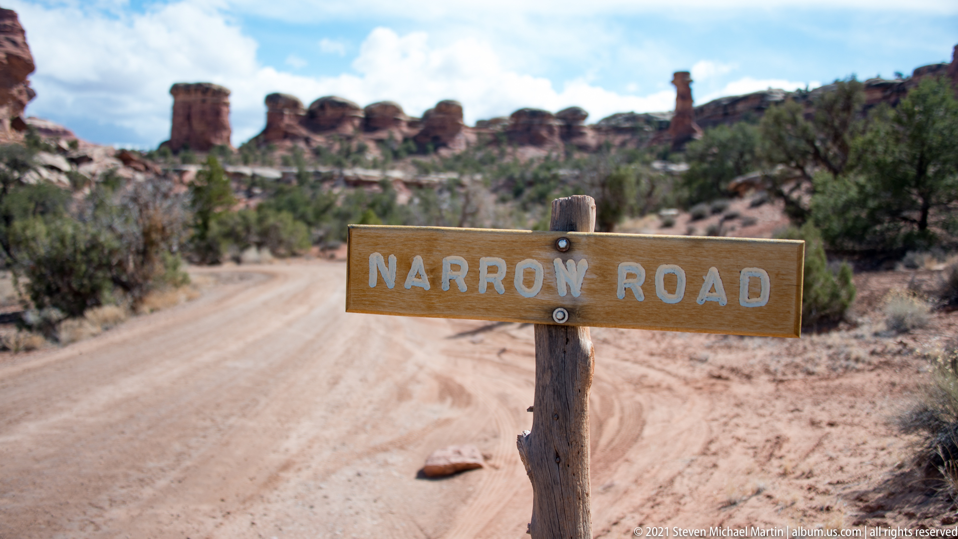
A weathered wooden sign marked “Narrow Road” stands in sharp focus beside a dusty track. Beyond it, the route recedes through low shrubs toward a softly blurred line of sandstone towers. The close framing turns a practical warning into the foreground subject while retaining the open, rocky terrain that makes the road feel isolated.
Caption
A weathered wooden sign marked “Narrow Road” stands in sharp focus beside a dusty track. Beyond it, the route recedes through low shrubs toward a softly blurred line of sandstone towers. The close framing turns a practical warning into the foreground subject while retaining the open, rocky terrain that makes the road feel isolated.

A broad red sandstone wall fills the middle ground, capped by irregular rounded blocks that form a broken skyline. Horizontal bedding and fractured ledges expose alternating textures, while pale rubble and scattered shrubs occupy the slope below. The close viewpoint makes the formation’s stacked structure more prominent than the surrounding park landscape.
Caption
A broad red sandstone wall fills the middle ground, capped by irregular rounded blocks that form a broken skyline. Horizontal bedding and fractured ledges expose alternating textures, while pale rubble and scattered shrubs occupy the slope below. The close viewpoint makes the formation’s stacked structure more prominent than the surrounding park landscape.

A long, flat-topped sandstone wall stretches across the middle distance, with a solitary high summit rising beyond it beneath a clouded sky. Pale bedrock and sparse vegetation frame the foreground, while shadows emphasize the canyon’s horizontal bands. The layered composition connects the nearby ledges to the more distant high country without fixing a specific landmark name.
Caption
A long, flat-topped sandstone wall stretches across the middle distance, with a solitary high summit rising beyond it beneath a clouded sky. Pale bedrock and sparse vegetation frame the foreground, while shadows emphasize the canyon’s horizontal bands. The layered composition connects the nearby ledges to the more distant high country without fixing a specific landmark name.

A steep, conical mesa rises from layered canyon country, topped by a narrow cluster of dark pinnacles. Pale sandstone shelves form the foreground and red ledges step across the middle distance. Heavy clouds gather behind the summit, separating its sharp profile from the softer, horizontal contours around it.
Caption
A steep, conical mesa rises from layered canyon country, topped by a narrow cluster of dark pinnacles. Pale sandstone shelves form the foreground and red ledges step across the middle distance. Heavy clouds gather behind the summit, separating its sharp profile from the softer, horizontal contours around it.

Broad sandstone slabs project over a recessed ledge, creating a shallow natural overhang above broken rock. Low shrubs and dry grasses spread across the foreground, and a cloudy sky opens above the formation. The image brings the eroded shelf close enough to reveal its stacked bedding while preserving the sparsely vegetated setting.
Caption
Broad sandstone slabs project over a recessed ledge, creating a shallow natural overhang above broken rock. Low shrubs and dry grasses spread across the foreground, and a cloudy sky opens above the formation. The image brings the eroded shelf close enough to reveal its stacked bedding while preserving the sparsely vegetated setting.

A slender sandstone pedestal supports a broad caprock, forming a balanced column against an open, clouded sky. Lower cliffs and scrub-covered ledges extend across the basin behind it, providing scale and context for the isolated form. Its narrow neck and heavier top make this tower stand out from the broader mesas nearby.
Caption
A slender sandstone pedestal supports a broad caprock, forming a balanced column against an open, clouded sky. Lower cliffs and scrub-covered ledges extend across the basin behind it, providing scale and context for the isolated form. Its narrow neck and heavier top make this tower stand out from the broader mesas nearby.

A rounded sandstone mass rises above a pale slickrock apron, its curved cap divided by dark seams and shallow ledges. Juniper and other low shrubs cluster around its base, while blue sky and thin clouds frame the upper contour. The close viewpoint gives the rock’s bulky, layered profile greater weight than the surrounding terrain.
Caption
A rounded sandstone mass rises above a pale slickrock apron, its curved cap divided by dark seams and shallow ledges. Juniper and other low shrubs cluster around its base, while blue sky and thin clouds frame the upper contour. The close viewpoint gives the rock’s bulky, layered profile greater weight than the surrounding terrain.

A massive sandstone tower occupies the left foreground, its darkened face rising above a broad basin of broken ledges and scrub. Smaller formations recede toward distant mesas under a bright, cloud-filled sky. The tower’s near position creates a strong scale contrast with the layered canyon landscape opening beyond it.
Caption
A massive sandstone tower occupies the left foreground, its darkened face rising above a broad basin of broken ledges and scrub. Smaller formations recede toward distant mesas under a bright, cloud-filled sky. The tower’s near position creates a strong scale contrast with the layered canyon landscape opening beyond it.

A small hiker crosses the open slickrock below a massive projecting sandstone shelf. The dark, rounded overhang dominates the upper frame, while the figure and scattered shrubs provide scale across the pale ground. This view makes the relationship between the traversable rock bench and the heavy cap above especially clear.
Caption
A small hiker crosses the open slickrock below a massive projecting sandstone shelf. The dark, rounded overhang dominates the upper frame, while the figure and scattered shrubs provide scale across the pale ground. This view makes the relationship between the traversable rock bench and the heavy cap above especially clear.

A hiker stands at the left of a broad, mushroom-shaped sandstone formation whose projecting cap spans a narrow supporting column. The low viewpoint makes the overhang appear especially wide, while the person supplies a clear measure of scale. Pale slickrock and thin clouds keep attention on the contrast between the compact figure and the massive sculpted rock.
Caption
A hiker stands at the left of a broad, mushroom-shaped sandstone formation whose projecting cap spans a narrow supporting column. The low viewpoint makes the overhang appear especially wide, while the person supplies a clear measure of scale. Pale slickrock and thin clouds keep attention on the contrast between the compact figure and the massive sculpted rock.

Two large, rounded sandstone formations stand in the foreground, framing a deep view into a basin of smaller towers. Bright cloud banks rise over the red rock skyline, and shrubs soften the lower edge. Their placement on opposite sides creates a natural window onto the clustered formations beyond.
Caption
Two large, rounded sandstone formations stand in the foreground, framing a deep view into a basin of smaller towers. Bright cloud banks rise over the red rock skyline, and shrubs soften the lower edge. Their placement on opposite sides creates a natural window onto the clustered formations beyond.

A broad red cliff stretches across the frame, its horizontal layers supporting a row of narrow pinnacles and rounded blocks. A low pale shelf runs along the base, while small shrubs punctuate the foreground. The close, level viewpoint makes the stacked structure of the formation and its irregular summit profile easy to compare.
Caption
A broad red cliff stretches across the frame, its horizontal layers supporting a row of narrow pinnacles and rounded blocks. A low pale shelf runs along the base, while small shrubs punctuate the foreground. The close, level viewpoint makes the stacked structure of the formation and its irregular summit profile easy to compare.

A broad sandstone ridge rises above pale bedrock and scattered grasses, its highest section broken into rounded towers and ledges. The red and cream layers alternate across the sloping face, while low shrubs mark the base. Sunlit cloud breaks clarify the formation’s irregular profile against the sky.
Caption
A broad sandstone ridge rises above pale bedrock and scattered grasses, its highest section broken into rounded towers and ledges. The red and cream layers alternate across the sloping face, while low shrubs mark the base. Sunlit cloud breaks clarify the formation’s irregular profile against the sky.

A maroon sign identifies Canyonlands National Park and the United States Department of the Interior’s National Park Service. It stands on two posts amid pale grasses and scattered rocks, with a juniper and low sandstone terrain behind it. The centered, readable lettering makes this a clear location marker within the landscape.
Caption
A maroon sign identifies Canyonlands National Park and the United States Department of the Interior’s National Park Service. It stands on two posts amid pale grasses and scattered rocks, with a juniper and low sandstone terrain behind it. The centered, readable lettering makes this a clear location marker within the landscape.

A steep, conical butte rises from a flat red-rock bench, with a jagged cluster of narrow pinnacles crowning its summit. Loose talus and horizontal bands mark the sloping sides, while pale clouds provide a soft backdrop. The isolated shape and sharp summit distinguish it from the lower, layered walls nearby.
Caption
A steep, conical butte rises from a flat red-rock bench, with a jagged cluster of narrow pinnacles crowning its summit. Loose talus and horizontal bands mark the sloping sides, while pale clouds provide a soft backdrop. The isolated shape and sharp summit distinguish it from the lower, layered walls nearby.

A long sandstone mesa stretches across the scene, its upper face marked by near-vertical grooves and sharply defined horizontal strata. The lower slope descends toward a dry basin of grasses and scattered shrubs, while a blue sky with thin clouds opens above. The broad profile foregrounds the mesa’s scale and stratified structure.
Caption
A long sandstone mesa stretches across the scene, its upper face marked by near-vertical grooves and sharply defined horizontal strata. The lower slope descends toward a dry basin of grasses and scattered shrubs, while a blue sky with thin clouds opens above. The broad profile foregrounds the mesa’s scale and stratified structure.

A bleached fallen trunk stretches across the foreground of a muted grassland, its twisted branches lying low against the ground. Beyond it, leafless trees line a shallow basin beneath a pale sandstone escarpment dusted with small patches of snow. The deadwood creates a strong horizontal counterpoint to the high, layered cliff.
Caption
A bleached fallen trunk stretches across the foreground of a muted grassland, its twisted branches lying low against the ground. Beyond it, leafless trees line a shallow basin beneath a pale sandstone escarpment dusted with small patches of snow. The deadwood creates a strong horizontal counterpoint to the high, layered cliff.
Canyonlands National Park — Field Guide
National Park Field Guide
📍 Overview
Canyonlands National Park preserves an extensive landscape of deeply eroded canyons, mesas, and buttes shaped by the Colorado and Green Rivers. Located within the Colorado Plateau, the park illustrates the long-term effects of tectonic uplift followed by gradual erosion that carved complex canyon systems through layered sedimentary rock. The scale of the landscape reflects geological processes operating over millions of years.
The park is divided into several districts, including Island in the Sky, The Needles, and The Maze, each presenting distinctive geological features formed through variations in erosion and rock composition. Exposed strata reveal changes in environmental conditions across prehistoric eras, while river systems continue to shape canyon depth and form. The landscape provides insight into the interaction between uplift, weathering, and water erosion.
⭐ Highlights
- Colorado and Green River canyon systems
- Island in the Sky mesa landscapes
- The Needles sandstone formations
- Layered sedimentary rock exposures
- Expansive Colorado Plateau desert scenery
🔎 Key Features
- Deeply incised canyon networks shaped by river erosion
- Sandstone formations formed through sediment deposition
- Mesas and buttes created by differential erosion
- Rock layers illustrating geological time sequences
- Large-scale desert landscape with minimal development
📷 Photography Notes
- Early and late light enhances canyon depth and texture
- Wide compositions help convey the scale of mesas and canyons
- Cloud shadows can add visual dimension to the landscape
- Layered rock patterns create natural compositional lines
- Foreground rock formations help provide depth
- Look for viewpoints that show river-carved canyon systems
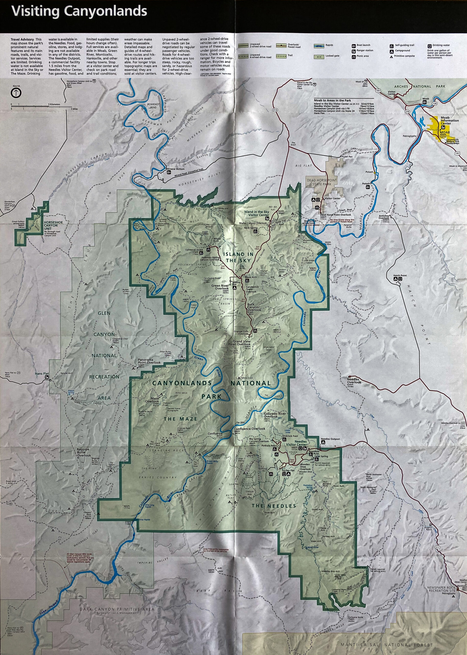
A printed visitor map fills the open brochure, with a large green-outlined park area, winding blue waterways, and a network of roads and labels. The map is surrounded by gray shaded terrain and folds down the center. This view emphasizes the park’s mapped extent and its relationship to nearby routes rather than a single scenic feature.
Caption
A printed visitor map fills the open brochure, with a large green-outlined park area, winding blue waterways, and a network of roads and labels. The map is surrounded by gray shaded terrain and folds down the center. This view emphasizes the park’s mapped extent and its relationship to nearby routes rather than a single scenic feature.

An open National Park Service brochure presents a panoramic photograph across its upper half and a grid of smaller landscape images and text below. The spread is arranged as a visitor overview, pairing scenic views with explanatory panels. Fine print is too small to transcribe from this reproduction, but the layout clearly identifies it as interpretive park material.
Caption
An open National Park Service brochure presents a panoramic photograph across its upper half and a grid of smaller landscape images and text below. The spread is arranged as a visitor overview, pairing scenic views with explanatory panels. Fine print is too small to transcribe from this reproduction, but the layout clearly identifies it as interpretive park material.
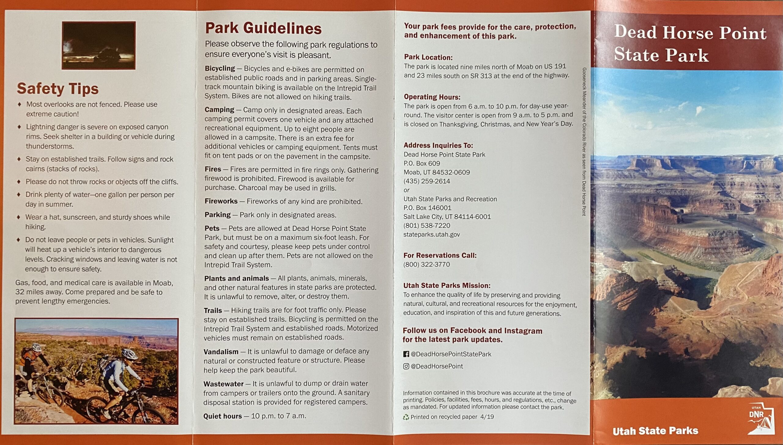
An open visitor guide places safety tips and park regulations across its central panels, with contact details and a tall canyon photograph on the right headed “Dead Horse Point State Park.” The close view shows how practical guidance and scenic imagery share the printed spread. Small body text is not legible enough here to quote reliably.
Caption
An open visitor guide places safety tips and park regulations across its central panels, with contact details and a tall canyon photograph on the right headed “Dead Horse Point State Park.” The close view shows how practical guidance and scenic imagery share the printed spread. Small body text is not legible enough here to quote reliably.
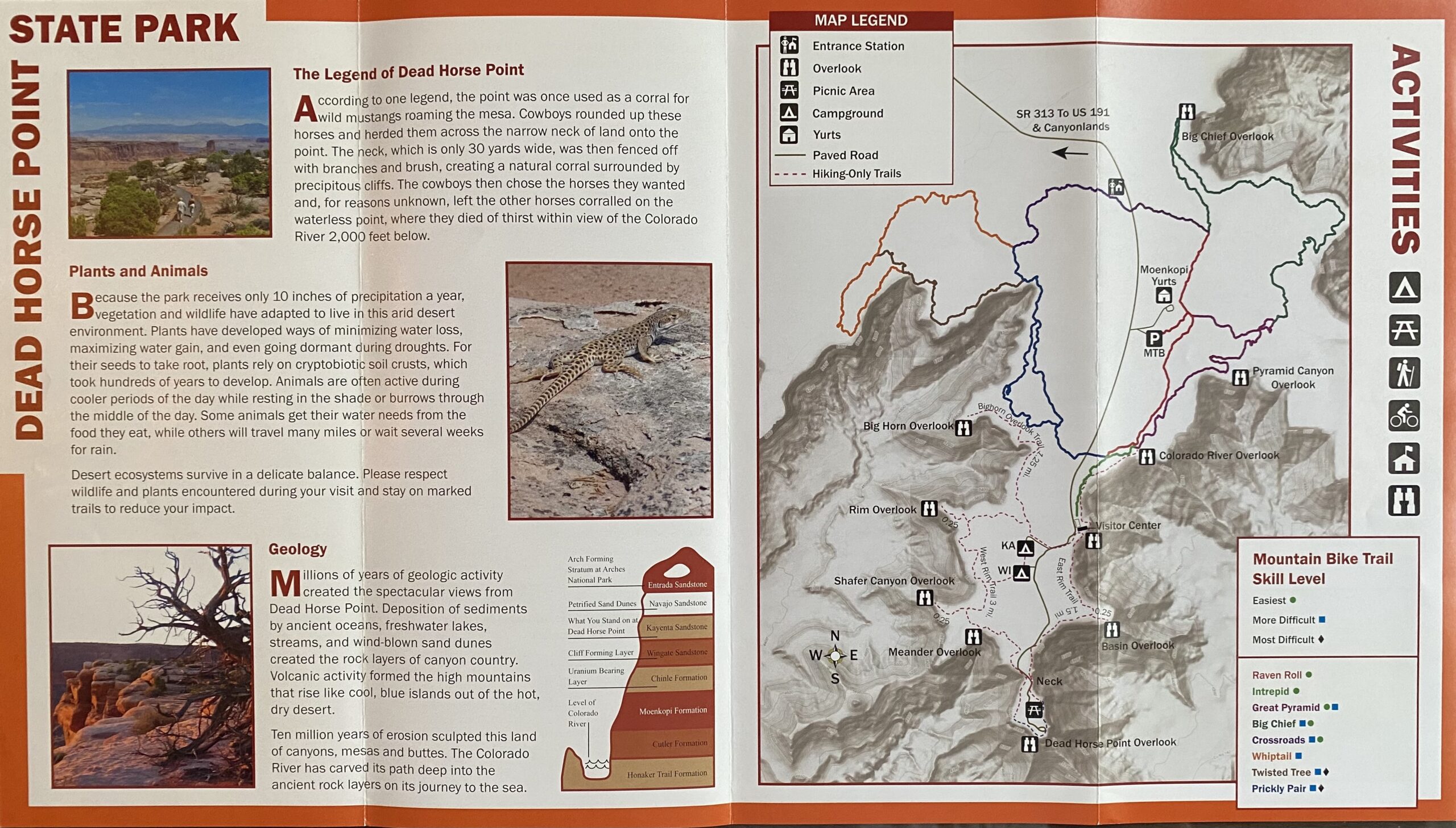
An open Dead Horse Point State Park guide combines a regional map with interpretive text and activity information. The map occupies the right half, marked with routes, facilities, and a legend; the left panel contains sections on plants and animals and geology, accompanied by small landscape photographs. Orange borders and vertical headings organize the brochure, presenting navigation and natural-history information in one printed spread.
Caption
An open Dead Horse Point State Park guide combines a regional map with interpretive text and activity information. The map occupies the right half, marked with routes, facilities, and a legend; the left panel contains sections on plants and animals and geology, accompanied by small landscape photographs. Orange borders and vertical headings organize the brochure, presenting navigation and natural-history information in one printed spread.